10.20.15
A gorgeous day in north Georgia . This is one of the overlooks on SR 136 . Even though it was late October , the leaves weren't showing very much color at lower elevations , but still not a bad view on this clear as a bell day .

I made a stop at Dawson Forest WMA on my way north . The gate to Long Road was open on the Burnt Mountain Tract . This was the first opportunity I had to check out this area . As you can see the Dakota has been replaced with a Jeep Cherokee . The 4WD allows me to go places I have no business going by myself .

Onward and upwards to the Blue Ridge WMA / Nimblewill area . There was definitely a bit more color on Winding Stair Gap Road .


Now that hunting season is in full swing more gated roads have been opened for hunter access . A quick word of caution ... check the hunting regulations available at GADNR for scheduled hunts . If you are going to wander around the woods this time of year , a safety orange vest is light weight and a potential lifesaver . We still have a few idiots , like in all activities . They will shoot at noise in the bushes . Make sure you can be seen please . All right , I will get off my soapbox now .
On FS 251 I spied a unique use of recycled materials . Although I must say the choice of an old toilet seat for this particular sign left me scratching my head . I thought it was for Shed Cemetery . Nope . There was a shed building and a cemetery .
The odd didn't stop with the sign . When I turned off into the cemetery there was a middle aged couple hiking down the road . So far , so ok . When I pulled into the cemetery lot it got down right weird . Right on the edge of the cemetery , right next to the graveyard , right next to the headstones , the couple had set up camp . Oh hell no !! I didn't stop to take pictures . I got busy turning around . That's when I saw the big red A on the side of the teardrop camper . Roll Tide my eye .
Well ... ok then . Maybe it's ok to camp with the spirits in Alabama . For me , I will never , not ever sit around a campfire singing Kumbayah , toasting s'mores with dead folks . I prefer my spirits in a bottle . ( BTW it's real name is Hickory Flats Cemetery and I am sure there are normal folks who visit it too . )


Back on FS 58 headed to the Three Forks area . The Noontootla Creek is formed from the confluence of Long Creek , Chester Creek , and Stover Creek . The actual confluence is hard to get to since it's in the middle of a laurel hell . The ''Toot'' as it's sometimes , called is an artificial lure only and a managed trophy trout stream with 16'' required for a keeper . Few and far between , there have still been a few caught .
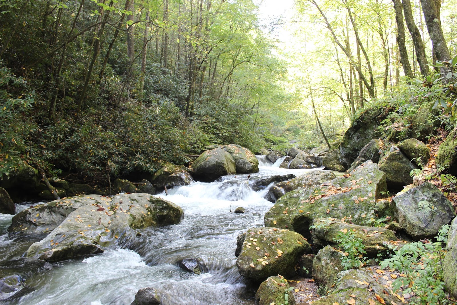
Long Creek is known for it's waterfalls . It is even marked on most Appalachian Trail maps . The AT and the Benton MacKaye follow Long Creek to where the two trails split . The namesake fall is actually on the Benton MacKaye trail .With all the rain we had lately I was excitedly anticipating a doozie . It was .
The path to the falls was wide and pretty easy going . Not what you think of when talking about the AT . There were roots and rocks to stub your toes on , two or three breath catcher climbs and three piddlin' rivulets to step across . Well , one was more like a full stride but you still didn't get your feet wet . Coming back was 90% down hill .


Several cascades and two other falls precede the namesake falls . I think one reason the other falls don't get the recognition of ''the '' falls is the degree of difficulty getting down to where you can get a good view . I didn't attempt one . The other falls was a quite a scramble up and down . The first pic is going down ,the second going up . About a 20' to 25' drop . Or climb .

The cascade and minor falls were pretty dang pleasant to look at as well as the sounds of the rushing waters .


At the main falls there was an enormous crowd of at least ten people . One family of five was taking photos in front of the falls on a boulder . The mom was helping the kids cross a slick log to get on the boulder to get a pic with dad one at a time . Being the busybody that I am , I offered to take a picture of the entire family . They actually thought I knew what I was doing and accepted my offer . One by one mom helped the kids cross the log as dad helped get them on the boulder . At last mom precariously inched her way across the log to join her loved ones . Of course she fell off !! I didn't want to laugh out loud . I held up one hand and told her I could only give her a score of five since she only went up to mid thigh . Had she not had a death grip on the log , she would have gotten a ten for full submersion . She gamely got back on the log , by herself I may add , and posed for their picture . A fall at the falls you could say . I had to give her kudos since she still had a one mile hike back to the trail head . It was a damn good picture if I say so myself .


A pleasant down hill hike back to the trailhead to the other side of 58 , a wide footbridge with a sturdy handrail crossed Chester Creek .


My game plan was to wander up to SR 60 and go to the Swinging Bridge . But... FS 58 follows the ''Toot '' as it meanders , sometimes rushing down Brushy Mountain and Bearden Mountain . The cascades easily visible out my window were my downfall . I had no choice but to stop and scramble down the steep bank to shoot a few photos .


After hauling my rather generous physique back up the bank to the road I caught my breath , loaded up , and headed to the Swinging Bridge . Touted as the longest suspension bridge of it's kind east of the Mississippi , it is 270' long . Actual length may vary depending on your source .
Just a piece down SR 60 , turn left on FS 816 . There is plenty of signage . The road to the trailhead isn't too rough and most cars can make it with no problems . Watch for logging trucks though . The USFS is thinning about a hundred acres or so alongside of the road . This should allow open areas of ''edge habitat '' that is vital to support deer and other critters .
The trailhead is a small , sides of the road parking area . There are no directional signs but the trail is fairly obvious . It's in line with the road . The path to the bridge has a ton of toe stubbing , ass busting roots and a few steep parts . A walking stick comes in mighty handy .
The bridge is solidly built and well braced . Huge hardware , cables , and concrete anchor this baby . Unlike the sketchy ones we crossed in a Tennessee state park .


The raw beauty of the Toccoa River goes on for mile after mile . If you are a canoe or kayak enthusiast the Toccooa River Trail is a must run . Years of conflict with property owners has been resolved with the help of the USFS . Now you can make the amazing 13 mile run from Deep Hole to Sandy Bottoms stress free . Be respectful of the property owners and stay in the river between public access points .


Another outstanding day on north Georgia public lands . You and I own these incredible natural resources and fall is a splendid time to enjoy them . Come on out and see them for yourself .